
Leg 205 Logging Summary
Shipboard Scientific Party
Introduction
ODP Leg 205, building on Leg 170 coring and logging-while-drilling (LWD) at the same sites, was designed to investigate the thermal structure and hydrological activity of the Costa Rica segment through a combination of downhole measurements and long-term sampling of fluids as well as monitoring of fluid pressure and temperature at critical horizons.
The science objectives for the leg were to determine the igneous and alteration history of the down going plate, to characterize the hydrogeological regime above and within the decollement, and to install long-term borehole observatories to monitor downhole pressure and temperature and sample fluids and gases. Three sites off Nicoya Peninsular, Costa Rica were drilled and two out of four long-term borehole observatories were successfully installed at two sites. Planned downhole logging at the seaward site was done only in igneous section beneath the sediments instead of the whole sediment and igneous section. A summary of the Leg 205 scientific results can be found in the Preliminary Report.
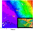
Figure 1. Bathymetric map showing sites of the Leg 205 (yellow) and Leg 170 (white dots) on the two seismic lines. Regional tectonic features are shown in the inset on the lower right.
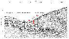
Figure 2. Sites from the Leg 205 (red lines) and Leg 170 (black lines) are shown on the migrated multichannel seismic profile BGR-99-44 across the Middle America Trench (from Leg 205 Preliminary Report, 2003).
Logging Operations
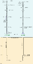
Figure 3. Configuration of downhole logging tools used at Hole 1253A and their operations summary.
Downhole logging was performed in Hole 1253A after it had been drilled to a depth of 600 mbsf with a 9 7/8" RCB drill bit. Hole 1253A was logged with two tool strings, the triple combination (Triple combo) and the FMS-sonic string (Figure 3). Previous LWD measurements taken during Leg 170 at Site 1039 did not include sonic or FMS, and reached only 407 mbsf (Kimura, Silver, Blum, et al., 1997). As expected, logging at Site 1253 was technically challenging. The first logging attempt failed to pass beneath 150 mbsf. Hence, 10-3/4" casing was installed beneath the sedimentary section into the upper sill to a depth of 413 mbsf. After the entire sediment section and part of the upper sill was cased, a second logging attempt was made, but was stopped again at 530 mbsf when the tool string lost communication due to a broken HLDS tool. The subsequent triple-combo run and first FMS-Sonic runs were successful up to 530 mbsf and second FMS-Sonic run was successful up to 564 mbsf (Figure 3).
Logging Results
Due to the mechanical problem with caliper 2 in FMS-Sonic tool string, a second pass of the tools was made in a 90o rotation from the orientation of the first pass, and thus gives a more complete picture of borehole shape (Figure 4).
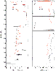
Figure 4. FMS caliper and pad 1 azimuth data from Runs 1 and 2.
The log data show a good correlation with the physical properties measurements from cores, particularly for the bulk density measurements. The logs can be clearly separated into three intervals on the basis of obvious changes in hole diameter, velocity, resistivity, bulk density, and porosity, corresponding to the upper igneous unit (gabbro sill), the sediments below, and the lower igneous unit (Figures 5A and 5B and Figure 6). These intervals generally correspond to the major lithology changes identified in the recovered cores. In the logged part of sill, (413-431 mbsf) porosities are low and densities, resistivities, and P-wave velocities are high. In the sedimentary section of enlarged borehole (431-461 mbsf) high porosities and low bulk densities, resistivities, and P-wave velocities identify sediments. A return to high bulk densities, resistivities, and P-wave velocities at 461 mbsf indicates the top of the lower igneous unit. The logs better identify the exact depth of the lower igneous unit than do core depths, because of partial recovery and the standard curatorial practices of moving any recovered material to the top of the core. The natural gamma ray is not distinctly different between the lower igneous and the sedimentary rocks. In contrast, there does appear to be a difference in natural gamma values between the upper igneous unit and the sediments and lower igneous units (Figure 5A and 5B).
A. 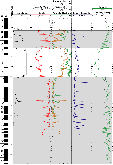 B.
B. 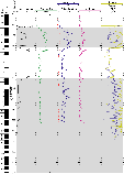
Figure 5. Three intervals divided from logs, upper gabbro, sediments and lower igneous units, are shown on summary log plots.
FMS images can be used to characterize structure and fabric in the igneous units. As the hole conditions were good in most of the igneous intervals, the textural and structural variation is clear between upper and lower sections and also shows differences within the lower igneous unit itself. The upper gabbro unit is generally characterized by blocky texture with ~0.5 m size blocks and 0.5 to 2 m spacing conductive features. However, the lower igneous unit is characterized by more conductive features (fractures or irregularities) and less blocky texture at the lower section. FMS images from the intervals into which the upper and lower osmo-samplers clearly showing dipping conductive features and irregular borehole shape (Figure 6).
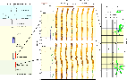
Figure 6. CORK-II OsmoSampler installed at Hole 1253A. FMS images processed in two different methods and preliminary results of its dip interpretation are shown together with two samplers (red color).
Magnetic field strength recorded by the general purpose inclinometer tool (GPIT) is in good correlation with general trend of the paleomagnetic measurements made from core. Sharp intensity changes at the depths of 412, 419, 435, 463 and 515 mbsf may be linked to lithologic changes. Additional detailed analyses are required to verify and quantify these initial, tentative observations.
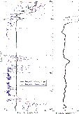
Figure 7. Magnetic field strength from the downhole logging measurements and magnetic intensity from the paleomagnetic measurements. Curve fit line is shown in red and detailed magnetic field strength is in small inset.
References
Shipboard Scientific Party, 1997. Site 1039. In Kimura, G., Silver, E., Blum, P., et al., Proc. ODP, Init. Repts., 170: College Station, TX (Ocean Drilling Program).
Schlumberger, 1989, Log interpretation principles/applications, Schlumberger Educational Services, Houston, TX.
Logging Scientist
K. T. Moe: Ocean Research Institute, University of Tokyo, 1-15-1 Minamidai, Nakano-ku, Tokyo 164-8639, Japan.